The Lonely Planet Editors on the 10 best hikes in Hawaiʻi. Kilauea Iki is on this list. Join us on our Volcano Hiking Adventure for the best hiking experience.
Hikers will find that mile for mile, the tiny islands of Hawaiʻi cannot be topped for heart-stopping vistas and soulful beauty. With its volcanoes and rain forests, spectacular cliffs and waterfalls, Hawaiʻi offers mountains to climb, lava deserts to explore and, most importantly, awe-inspiring views. Here’s a look at some of the best hikes Hawaiʻi has to offer.
Kaʻena Point Trail
Best hike for ocean views
5 miles roundtrip, 2 hours, easy to moderate
The Kaʻena Point hike (in Oʻahu) offers extraordinary views the entire way, with the ocean on one side and craggy cliffs on the other. You can do it in either direction, starting from either Keawaʻula Beach in the south – where you’ll find the last real restrooms and a small car park – or at the trailhead at the end of Hwy 930 in the north. You’ll have to arrange a pick-up if you don’t want to do a 10-mile round-trip.
Driving between the two trailheads, via Ko Olina, Pearl City and Dillingham Airfield, is a whopping 51 miles.
As you start walking from the Kaʻena Point Trailhead, you’ll see traces of the original use of this trail: the railway that hauled sugarcane all the way from the North Shore to Honolulu, which is why the path is so level and easy to walk.
Look for tide pools, sea arches and blowholes that occasionally come to life on high surf days. In addition to native and migratory seabirds, you might spot Hawaiʻian monk seals laid out on the rocks or the sand – don’t disturb these endangered creatures.
At the halfway mark of the hike is Kaʻena Point, which has remarkable views out over the white-capped Pacific. Here at the westernmost point on Oʻahu, winter waves can reach 50 feet.
Assuming you’ve found an obliging person to give you a lift from the end of the trail, continue east to the north trailhead. Look for whales in winter navigating the rough, storm-tossed ocean. Many of these swells started in Alaska and beyond. At any time, you may see albatrosses overhead.
Tips for hiking the Kaʻena Point Trail: The trail is extremely exposed and lacks any shade, so take sunscreen and plenty of water and hike during the cooler parts of the day. Be cautious near the shoreline as there are strong currents, and rogue waves can reach extreme heights. At various places you may find that landslides have blocked parts of the trail; simply climb up and over to continue your journey.
Kuliʻouʻou Ridge Trail
Best hike for gorgeous summit views
4 miles roundtrip, 4 hours, moderate to difficult
West of Oʻahu, this route is open to both hikers and mountain bikers. The trail winds up forest switchbacks before making a stiff but ultimately satisfying 1800-foot climb along a ridgeline to a windy summit offering 360-degree views of Koko Head, Makapuʻu Point, the Windward Coast, Diamond Head and downtown Honolulu.
The trail is not always well maintained and may be partly overgrown with vegetation. Start from the Na Ala Hele trailhead sign at the end of Kalaʻau Place, which branches right off Kuliʻouʻou Rd, just over 1 mile north of the Kalanianaʻole Hwy (Hwy 72).
Pololu Valley Lookout & Trail
Best hike for lookout views
3 miles roundtrip, 2-4 hours, difficult
There’s a dramatic finality to the Pololu Valley, located on the Big Island of Hawaiʻi. You get here and see a verdant, wild space.
The entirety of the valley feels deeply primeval, and it’s easy appreciate why native Hawaiʻians considered the area rich in mana (cosmic energy). The word Pololu means “long spear,” and that’s a fitting appellation – the valley looks as if it were carved out of the jungle and mountains by a vengeful deity.
Even if you don’t want to walk this path to its conclusion, you should really attempt, at the very least, the start of this trail. The view into the valley from the Hwy 270 lookout is much improved if you are able to endure a couple of switchbacks.
The valley floor is about a third of a mile below the beginning of the trailhead. The floral fecundity of Pololu seems to shift into high gear as soon you hit the floor; the trees are lush on the way down, but they turn positively alien down here. You’ll need to cross the (shallow, sometimes dry) Pololu River where it flows into the sea to keep going.
Marvel at the beautiful beach and don’t venture into the water – the currents around here are particularly dangerous. From here you’ll walk on flat, verdant ground east into the valley; this short jaunt is about 0.40 miles long.
Keep your eyes peeled for a faint, upward climbing trail that wends for just over a mile through humid rainforest to the Honokane Nui Valley Lookout. The view is as lovely as you might expect: this is a showstopping lookout, located in a valley that is already incredible.
Kilauea Iki
Best day hike
4.5 miles, 2-3 hours, moderate to difficult
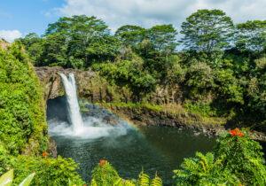
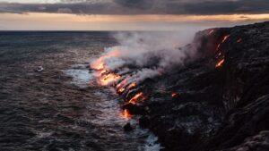
If you can only do one day hike, make it this one, located in Hawaiʻi Volcanoes National Park. Do the loop counterclockwise through an astounding microcosm of the park that descends through fairy-tale ohia forests to a mile-wide, still-steaming lava lake that was filled relatively recently by a fiery fountain spewing 403 million gallons of lava per second.
Kilauea Iki erupted for five weeks at the end of 1959, filling the crater with several meters of lava that washed against its walls like ocean waves and then drained back into the fissure. The lava fountain that formed the cinder pile above reached 1900 feet, the highest ever recorded in Hawaiʻi.
This awesome sight turned terrifying when boulders blocked the passage like your thumb on a garden hose, sending a jet of lava shooting across the crater toward crowds of visitors.
To fully appreciate this hike, first watch the excellent vintage film, Eruption of Kilauea 1959–1960 at Kilauea Visitor Center or online, then grab an informative brochure ($2, or download it from the park’s website).
Tips for hiking Kilauea Iki: Hit the trail before 8am to beat the crowds. The faint footpath across the crater floor is marked by ahu (stone cairns) to aid navigation. Follow them; the crust can be thin elsewhere.
Keoneheʻeheʻe (Sliding Sands) Trail
17.8 miles round-trip; two days, difficult
Best overnight hike
The Sliding Sands path descends into an unearthly world of stark lava sights and ever-changing clouds. The trailhead is at the entrance to Maui’s Haleakalā Visitor Center parking lot, beside Pa Kaʻoao (White Hill). This hike is best done in two days, so secure a Paliku camping or cabin permit in advance.
The first thing you’ll notice? The silence. The only sound is the crunching of volcanic cinders beneath your feet. If you’re pressed for time, just descending 20 minutes will reward you with an into-the-crater experience and fabulous photo opportunities. The climb out, unfortunately, takes nearly twice as long.
The first six miles follow the southern wall, with great views. Vegetation is minimal, but you may see green kūpaoa plants and shimmering silverswords. At the first major overlook, after the long straightaway, you can see cinder cones dotting the bottom of the crater.
The views only improve from here. Switchbacks drop from the overlook. A spur trail to Ka Luʻu o ka Ōʻō cinder cone, which arises to your left about 2 miles down, has been closed. Enjoy the view from where you are. Next up? A field of silverswords. After that a narrow path squeezes through a tall lava formation, framing the peaks ahead.
Four miles down, after an elevation drop of 2500 feet, Keoneheʻeheʻe Trail intersects with a spur that leads north into the cinder desert, where it connects with the Halemauʻu Trail after 1.6 miles. Continuing on Keoneheʻeheʻe, head across the crater for two miles to Kapalaoa.
Verdant ridges rise on your right, giving way to ropy pahoehoe (smooth-flowing lava). Kapalaoa is reached after roughly four hours. From here to Paliku, the descent is gentle and the vegetation gradually increases.
Paliku (6380 ft) is beneath a sheer cliff at the eastern end of the crater. In contrast to the crater’s barren western end, this area receives heavy rainfall, with ohia forests climbing the slopes.
Pipiwai Trail
Best hike for adventure
4 miles round trip, 2 hours, moderate
Ready for an adventure? This super-fun trail ascends alongside the ʻOheʻo stream bed in Haleakalā National Park, rewarding hikers with picture-perfect views of waterfalls and an otherworldly trip through a bamboo grove. The trail starts on the mauka (inland) side of the visitor center and leads up to Makahiku Falls (0.5 miles) and Waimoku Falls (2 miles). To see both falls, allow about two hours return.
Along the path you’ll pass large mango trees and patches of guava before coming to an overlook after about 10 minutes. Makahiku Falls, a long bridal-veil waterfall that drops into a deep gorge, is just off to the right. Thick green ferns cover the sides of 200-foot basalt cliffs where the water cascades – a rewarding scene for such a short walk.
Continuing along the main trail, you’ll walk beneath old banyan trees, cross Palikea Stream (bug spray advisable here) and enter the wonderland of the Bamboo Forest, where thick groves of bamboo bang together musically in the wind.
The upper section is muddy, but boardwalks cover most of the mud. Beyond the bamboo forest is Waimoku Falls, a thin, lacy 400-foot waterfall dropping down a sheer rock face. When you come out of the first grove you’ll see the waterfall in the distance. Forget swimming under Waimoku Falls – its pool is shallow and there’s a danger of falling rocks.
Tip for hiking the Pipiwai Trail: The trail can be muddy, so make sure you have the right gear. Wear grippy water shoes for this one.
Waiheʻe Ridge Trail
Best hike for variety
5 miles roundtrip, 3 hours, moderate
For jaw-dropping views over the long, lush carpets of Waihe’e Gorge, cascading waterfalls, tropical forests and a bird’s eye view of Wailuku and Maui’s wild northern coast, it doesn’t get much better than the Waihe’e Ridge Trail.
To get to the trailhead, take the one-lane paved road that starts on the inland side of the Kahekili Hwy just south of the 7-mile marker in Maui. You’ll find parking before the trailhead (currently open 7am to 7pm). Begin your walk by climbing a sheer concrete ramp, and pass blue water tanks on the right.
Suitable for solo walkers, fit seniors and active kids, the initial path is a bit steep and can get swampy – Waihe‘e means “slippery water” in Hawaiʻian, but don’t let this dishearten you. It’s a fairly steady climb to the 2563-foot summit of Lanilili Peak, but it’s not a strenuous one.
Be prepared to walk back down the mountain afterwards. There are intervals of flat terrain throughout the trail. It’s best to bring good walking shoes to tackle mud, stones and exposed tree roots. Set off before 8am to beat the heat and the clouds, which can obscure the view later in the morning.
Perhaps grab one of the walking sticks/tree branches, often left behind by hikers, at the gate leading onto the trail, if you are in need of some extra support.
Starting at an elevation of 1000 feet, it’s already possible to spy the vast blue ocean. The trail, which crosses reserve land, climbs a ridge, passing from mainly shaded humid woodland areas of ancient undergrowth to open pastures nearer the summit.
Guava trees and groves of eucalyptus are prominent, and the aroma of fallen fruit may accompany you after a rainstorm. From the 0.75-mile post, panoramic views open up, with a scene that sweeps clear down to the ocean along the Waiheʻe Gorge and deep into pleated valleys.
Continuing on, you’ll enter ‘ohi‘a forest; look out for butterflies and native birds like the bright crimson ʻapapane. A clearing offers a bench in prime view of the cascading Makamaka‘ole Falls in the distance. On the ridge, views are similar to those you’d see from a helicopter, and you’ll probably see a handful of them dart into the adjacent valley like gnats on a mission.
There are several natural pausing places along the trail to stop and soak up the scenery and remarkable stillness. Birdsong, chirping insects, a rushing stream, muffled bits of hiker conversation below – these are the only interruptions.
The trail ends with a series of sharp bends and a steep climb to a picnic table on the 2563-ft peak of Lanilili. You’ll be rewarded with a staggering 360-degree view, and with clear skies it’s possible to see Haleakalā volcano in the distance. If it’s foggy, wait about 10 minutes or so; it may blow off.
The Division of Forestry and Wildlife claims 50 to 100 people hike the trail daily, so expect company.
Kalalau Trail/Keʻe Beach to Hanakapiʻai Beach
Best hike for panoramic views
4 miles roundtrip, 4 hours, moderate to difficult
The Kalalau Trail begins with a steep uphill ascent from its Ke‘e Beach trailhead. For the first half-mile much of the path is cobbled, but it’s still quite a climb. Fortunately it’s also beautiful, with lush tropical vegetation and superb views.
A mile along, at the highest point on this stretch – 400 ft above the ocean – vast panoramas open up ahead, looking westward along the coast. The trail then winds through successive hanging valleys, crossing trickling cascades at each inland curve before veering back out to the next headland.
It takes most hikers approaching two hours to complete the 2-mile trek to Hanakapi‘ai Beach. As the trail drops back down to the sea, you have to cross broad Hanakapi‘ai Stream; a helpful rope is often strung between the banks.
The white-sand beach at the river mouth is constantly re-configured by the waves and may take the form of a sandbar, cut off beyond a small lagoon. Be warned, though: numerous hikers have drowned here, and it’s never safe for swimming.
Access to Ha‘ena State Park, where the Kalalau Trail begins, requires an advance reservation, and anyone planning to overnight on the trail needs a permit. Reserve both at the state park website.
Cliff & Canyon Trails
Best hike for canyon views
3.6 miles roundtrip, 1 hour and 30 min, moderate
For some of the best family hiking in Kauaʻi ‘s Kokeʻe State Park, set off along the straightforward 0.1-mile Cliff Trail, which starts 0.8 miles down Halemanu Rd. Enjoy the canyon views, then keep going on the forested, 1.7-mile Canyon Trail, which descends steeply before reaching a vast red-dirt promontory, poised above stark cliffs. Just beyond, some huff-and-puff climbing brings you to Waipoʻo Falls.
If you’ve had enough, turn around at the falls. Otherwise, follow the trail across the stream to the canyon rim. It ends at Kumuwela Lookout, where you can rest at a picnic table before backtracking to Halemanu Rd.
For an alternate return route, make a right at the signed intersection with the Black Pipe Trail at the top of the switchback where you leave the canyon rim. This half-mile route ends at the 4WD road, where you turn left (downhill) and walk back to where you started.
If you have a 4WD, you can skip the steep trek by accessing the trail system from the end of Kumuwela Ridge.
Awaʻawapuhi Trail
Best hike in Kōke‘e
6.2 miles roundtrip, 4-5 hours, moderate
Arguably the best trail in Kokeʻe, measuring 3.1 miles one way, the Awaʻawapuhi Trail culminates in unsurpassable vistas from the Awaʻawapuhi Lookout, 2500 ft above the Na Pali coast. While demanding considerable stamina, it’s less steep or technical than the Nuʻalolo Trail nearby, and makes a better fit for families. It starts alongside Kokeʻe Rd, 1.7 miles uphill beyond the lodge.